
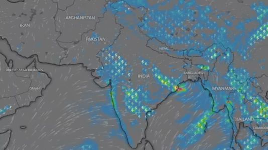
The monsoon system bringing welcome showers and cooler temperatures to Delhi this week is also expected to create dangerous weather conditions across Uttarakhand and Himachal Pradesh. While the rain originates from the same weather system, the mountainous terrain of the Himalayas dramatically changes how it behaves, increasing the risk of cloudbursts, flash floods, and landslides.
A Bay of Bengal monsoon depression is forecast to push moisture across northern India on July 28 and 29, with the greatest threat expected in the Himalayan region.
Why Does the Same Rainfall Become More Dangerous in the Hills?
The key difference lies in the landscape.
Across the plains of Delhi, Haryana, and surrounding regions, moisture-laden air moves relatively freely, producing widespread and generally moderate rainfall.
However, when these moisture-filled winds reach the Himalayan foothills, they encounter towering mountain ranges. Unable to move through them, the air is forced upward in a process known as orographic lifting.
As the air rises:
- Atmospheric pressure decreases.
- The air expands and cools.
- Cooler air holds less moisture.
- Water vapour rapidly condenses into rain.
This natural process causes mountains to extract far more rainfall from the same clouds than nearby plains.
What Is Orographic Lifting?
Orographic lifting is a meteorological phenomenon in which moist air is forced to rise over elevated terrain.
As the air ascends mountain slopes, it cools quickly, leading to rapid cloud formation and heavier rainfall. This is why Himalayan regions frequently record much higher rainfall totals than nearby cities experiencing the same monsoon system.
In simple terms, mountains act like a giant sponge squeezing moisture from passing clouds.
What Is a Cloudburst?
A cloudburst is an extremely intense rainfall event where more than 100 millimetres of rain falls within one hour over a small area.
Such rainfall can overwhelm natural drainage systems almost instantly.
Mountain regions are particularly vulnerable because:
- Moist air continues rising along steep slopes.
- Thunderclouds grow vertically and accumulate enormous quantities of water.
- Rain falls over narrow valleys rather than spreading across wide plains.
The result is sudden, localized flooding capable of causing severe destruction within minutes.
Why Cloudbursts Trigger Flash Floods and Landslides
Heavy rainfall becomes especially dangerous in mountainous terrain because gravity accelerates water movement.
Rainwater rapidly flows downhill, merging into streams and rivers that can swell dramatically in a short time.
At the same time:
- Water saturates the soil.
- Hillsides lose stability.
- Rocks, mud, and debris begin sliding downhill.
- Roads, bridges, homes, and infrastructure can be severely damaged.
Unlike flooding in flat regions, mountain floods often develop with little warning, making evacuation far more difficult.
How the Bay of Bengal Depression Is Driving This Weather
The current weather pattern is being driven by a monsoon depression over the northwest Bay of Bengal near the Odisha coast.
As it moves inland, it pulls moisture across eastern, central, and northern India.
The system is expected to bring rainfall in phases:
- July 27: Odisha, Jharkhand, and parts of central India.
- July 28–29: Delhi, Haryana, Punjab, Uttar Pradesh, Uttarakhand, and Himachal Pradesh.
While Delhi is expected to experience cooler temperatures and moderate rainfall, the same moisture interacting with the Himalayas significantly raises the possibility of cloudbursts and landslides.
Rainfall May Shift Westward Later This Week
Meteorologists expect the Bay of Bengal depression to gradually weaken over central India later in the week.
Meanwhile, the Arabian Sea branch of the southwest monsoon is forecast to strengthen, increasing rainfall activity over:
- Gujarat
- Saurashtra
- Kutch
However, the most immediate concern remains the Himalayan states, where weather conditions are expected to remain highly unstable during the peak rainfall period.
Safety Advisory for Travelers
People planning to travel through Uttarakhand or Himachal Pradesh over the next few days should closely monitor official weather updates.
Authorities generally advise travelers to:
- Avoid unnecessary travel during heavy rainfall.
- Stay away from rivers, streams, and landslide-prone areas.
- Follow local administration advisories.
- Be prepared for road closures and traffic disruptions in hilly regions.
As monsoon activity intensifies, understanding how geography influences rainfall can help residents and travelers stay prepared for rapidly changing weather conditions.
FAQs
1. Why is the same monsoon rain more dangerous in Uttarakhand than in Delhi?
Mountains force moisture-laden air to rise through orographic lifting, producing much heavier rainfall that can trigger cloudbursts, flash floods, and landslides.
2. What is orographic lifting?
Orographic lifting occurs when moist air is forced upward by mountains, causing it to cool, condense, and produce intense rainfall.
3. What is a cloudburst?
A cloudburst is an extreme rainfall event in which more than 100 mm of rain falls within one hour over a small area.
4. Why do cloudbursts often occur in mountainous regions?
Steep terrain forces moist air to rise continuously, allowing storm clouds to build rapidly and release large amounts of rain over a limited area.
5. Which areas are expected to face the highest rainfall risk?
Uttarakhand and Himachal Pradesh are expected to face the highest risk of cloudbursts, flash floods, and landslides during July 28–29.
6. What is causing the current rainfall across North India?
A monsoon depression over the northwest Bay of Bengal is carrying moisture across eastern, central, and northern India.
7. Will Delhi experience heavy rain?
Delhi is expected to receive widespread rainfall and cooler temperatures, but the weather is generally less hazardous than in nearby Himalayan regions.
8. Why do landslides happen after heavy rain?
Heavy rainfall saturates soil on steep slopes, reducing stability and causing rocks, mud, and debris to slide downhill.
9. Which regions may receive increased rainfall later this week?
As the Bay of Bengal system weakens, rainfall is expected to increase over Gujarat, Saurashtra, and Kutch due to strengthening monsoon winds from the Arabian Sea.
10. What precautions should travelers take during heavy monsoon conditions?
Travelers should monitor weather advisories, avoid flood-prone and landslide-prone areas, postpone unnecessary journeys during severe weather, and follow instructions from local authorities.