
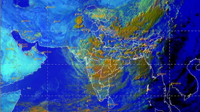
India is expected to experience an active spell of monsoon weather over the next four days as a deep depression moving inland from Odisha interacts with a Western Disturbance over the western Himalayas. The combined impact of these two weather systems is likely to trigger widespread heavy rainfall, thunderstorms, flash floods, and travel disruptions across several parts of the country.
Weather experts say the interaction between the moisture-rich monsoon system and the Western Disturbance could significantly increase rainfall intensity across north and central India.
Two Powerful Weather Systems to Boost Rainfall
Satellite observations indicate that the deep depression, which crossed the Odisha coast, has moved inland while carrying large volumes of moisture into central India. At the same time, an active Western Disturbance is influencing weather conditions over Jammu and Kashmir and the western Himalayan region.
The interaction between these systems is expected to strengthen atmospheric instability, leading to prolonged spells of rain, thunderstorms, and localized heavy downpours.
States Likely to Receive Heavy Rainfall
According to weather forecasts, moderate to heavy rainfall is expected across:
- Madhya Pradesh
- Chhattisgarh
- Maharashtra
- Telangana (parts)
Rainfall is also likely to intensify over:
- Punjab
- Haryana
- Delhi-NCR
- Uttar Pradesh
- Uttarakhand
- Himachal Pradesh
- Jammu and Kashmir
The wet spell is expected to continue for the next 72 to 96 hours.
Flash Floods and Landslide Risk Increases
Meteorologists note that when a deep monsoon depression combines with a Western Disturbance, rainfall often becomes more widespread and intense.
Such weather patterns have historically produced some of the season’s heaviest rain events across northern India.
Authorities have warned of:
- Flash floods in low-lying areas
- Waterlogging in urban centers
- Rising river levels
- Landslides in hilly regions
- Reduced visibility during heavy rain
- Localized thunderstorms
Residents living in flood-prone districts and mountainous areas have been advised to remain vigilant.
Travel Disruptions Expected
Heavy rainfall could affect transportation across multiple regions.
Possible disruptions include:
- Slow-moving traffic due to waterlogging
- Road closures in flood-affected areas
- Rail service delays
- Flight disruptions caused by poor weather conditions
- Longer travel times during peak rainfall periods
Commuters are advised to check weather and traffic updates before planning journeys.
Weather Systems Under Close Watch
Meteorologists are closely monitoring the movement of both the deep depression and the Western Disturbance.
Even small changes in their track, timing, or intensity could alter rainfall distribution across several states.
Weather agencies expect monsoon activity to remain vigorous throughout the week, bringing much-needed rainfall to many regions while increasing the risk of weather-related emergencies.
Safety Tips During Heavy Rainfall
Residents in affected areas should:
- Avoid unnecessary travel during intense rainfall.
- Stay away from flooded roads and overflowing drains.
- Follow weather advisories issued by local authorities.
- Keep emergency supplies, including drinking water and essential medicines, ready.
- Exercise caution in landslide-prone and hilly regions.
- Monitor official weather updates regularly.
FAQs
1. Why is heavy rainfall expected over the next four days?
The interaction between a deep depression moving inland from Odisha and an active Western Disturbance is expected to strengthen monsoon activity.
2. Which states are likely to receive heavy rain?
Madhya Pradesh, Chhattisgarh, Maharashtra, Telangana, Punjab, Haryana, Delhi-NCR, Uttar Pradesh, Uttarakhand, Himachal Pradesh, and Jammu & Kashmir are among the regions expected to receive heavy rainfall.
3. What is a deep depression?
A deep depression is a strong low-pressure weather system that carries large amounts of moisture and often produces widespread heavy rainfall.
4. What is a Western Disturbance?
A Western Disturbance is a weather system that originates over the Mediterranean region and brings rain and snowfall to northern India, especially during certain seasons.
5. What risks are associated with this weather system?
Flash floods, landslides, waterlogging, river swelling, traffic congestion, and transport disruptions are among the major risks.
6. How long will the intense monsoon spell last?
Current forecasts indicate active monsoon conditions for approximately 72 to 96 hours.
7. Can rainfall forecasts change?
Yes. Slight changes in the movement or intensity of the weather systems can affect rainfall distribution and intensity.
8. Will urban areas be affected?
Yes. Cities may experience waterlogging, traffic jams, flight delays, and rail disruptions during periods of heavy rainfall.
9. What precautions should people take?
Avoid flood-prone areas, monitor official weather updates, limit travel during heavy rain, and follow local advisories.
10. Why do interacting weather systems produce heavier rainfall?
The combination of abundant moisture and increased atmospheric instability often leads to prolonged and intense rainfall events.