
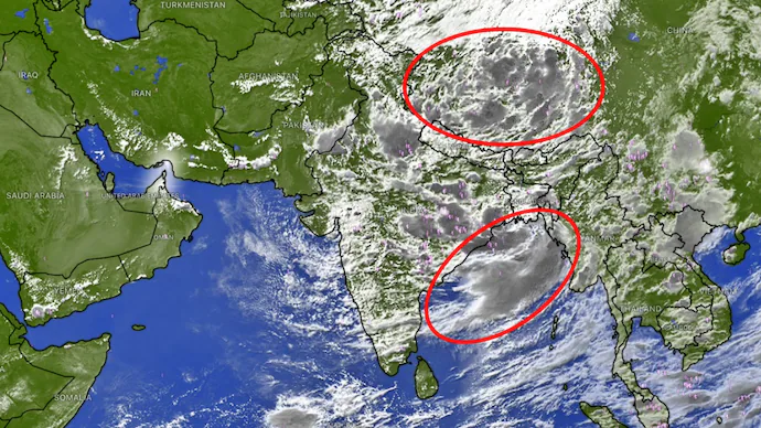
India is witnessing one of the most active phases of the 2026 southwest monsoon as two powerful weather systems interact over the subcontinent, significantly boosting rainfall activity. According to the India Meteorological Department (IMD), the convergence of a deep Bay of Bengal depression and a large upper-level monsoon circulation over the Tibetan Plateau is expected to trigger widespread thunderstorms, heavy rainfall, and an increased risk of flooding in several regions.
Meteorologists say this rare atmospheric alignment is strengthening the monsoon flow and expanding rain-bearing systems across eastern, central, northern, and southern India.
Two Major Monsoon Systems Fuel Widespread Rainfall
Satellite observations indicate that a massive monsoon circulation remains active over the Tibetan Plateau, while a deep depression—originating from a low-pressure system over the Bay of Bengal—has moved inland after crossing the West Bengal–North Odisha coast.
The interaction between these two large-scale weather systems is creating ideal conditions for continuous cloud development, enhanced moisture transport, and widespread rainfall across the country.
Bay of Bengal Depression Strengthens Monsoon
The IMD stated that the deep depression will continue moving north-northwest, carrying huge amounts of moisture from the Bay of Bengal deep into the Indian mainland.
As the system progresses inland, it is interacting with the active monsoon trough stretching across northern India. This combination is expected to strengthen thunderstorms and intensify rainfall over a vast geographical area.
Rainfall has already increased across eastern India and is forecast to spread further toward central, northern, and western regions over the coming days.
States Under Heavy Rain Alert
The IMD has forecast heavy to very heavy rainfall across several states, including:
- Odisha
- West Bengal
- Jharkhand
- Bihar
- Chhattisgarh
- Madhya Pradesh
- Uttar Pradesh
- Delhi
- Haryana
- Punjab
- Uttarakhand
- Himachal Pradesh
Meanwhile, thunderstorms and moderate to heavy rainfall are also expected across:
- Maharashtra
- Telangana
- Karnataka
- Kerala
- Coastal regions along the western coast
Why Are These Weather Systems So Powerful?
Weather experts explain that the upper-level circulation over the Tibetan Plateau plays a crucial role in strengthening the southwest monsoon by influencing atmospheric winds at higher altitudes.
At the same time, the Bay of Bengal depression functions as a powerful moisture source, continuously drawing warm and humid air inland.
When these two systems interact, they reinforce each other by:
- Increasing atmospheric instability
- Enhancing cloud formation
- Boosting thunderstorm development
- Producing widespread and intense rainfall
This interaction has already generated clusters of thunderstorms across eastern, central, northern, and southern India.
Floods and Landslide Risk Likely
With persistent rainfall expected through the week, the IMD has advised residents in vulnerable regions to remain cautious.
Potential weather-related hazards include:
- Urban waterlogging
- Flash floods
- River overflow
- Landslides in hilly areas
- Traffic disruptions
- Reduced visibility during thunderstorms
The Himalayan states, especially Uttarakhand and Himachal Pradesh, remain particularly vulnerable due to steep terrain, where prolonged rainfall can quickly trigger landslides and flash floods.
One of the Strongest Monsoon Spells This Season
Meteorologists believe the current interaction between the Bay of Bengal depression and the Tibetan Plateau circulation could produce one of the most widespread monsoon spells of the season.
While the rainfall is expected to benefit regions facing rainfall deficits, authorities are urging people in flood-prone and low-lying areas to monitor official weather advisories and avoid unnecessary travel during periods of intense rainfall.
As the southwest monsoon continues to strengthen, weather experts expect active rainfall conditions to persist across large parts of India over the next several days.
FAQs
1. Why is heavy rainfall expected across India?
Heavy rainfall is being triggered by the interaction between a deep Bay of Bengal depression and a strong monsoon circulation over the Tibetan Plateau.
2. Which states are likely to receive heavy rain?
Odisha, West Bengal, Bihar, Jharkhand, Uttar Pradesh, Delhi, Haryana, Punjab, Madhya Pradesh, Chhattisgarh, Uttarakhand, Himachal Pradesh, Maharashtra, Telangana, Karnataka, and Kerala are among the affected states.
3. What is a monsoon depression?
A monsoon depression is a low-pressure weather system that carries large amounts of moisture and often causes widespread rainfall and thunderstorms.
4. What role does the Tibetan Plateau play in the monsoon?
The Tibetan Plateau influences upper-level atmospheric circulation, helping strengthen the southwest monsoon and enhance rainfall.
5. What weather hazards are expected?
Flooding, waterlogging, flash floods, landslides, thunderstorms, and traffic disruptions are possible in several regions.
6. Why are Himalayan states at greater risk?
Steep mountain terrain causes rainwater to accumulate rapidly, increasing the chances of flash floods and landslides.
7. Will southern India also receive rain?
Yes. Maharashtra, Telangana, Karnataka, Kerala, and parts of the west coast are expected to witness thunderstorms and moderate to heavy rainfall.
8. How long is this active monsoon spell expected to continue?
The current weather pattern is expected to remain active through the week, according to meteorological forecasts.
9. Can this rainfall help drought-affected regions?
Yes. The widespread rainfall may improve water availability and reduce rainfall deficits in several regions.
10. What precautions should people take?
Residents should follow IMD advisories, avoid flooded roads, stay alert in landslide-prone areas, and prepare for possible travel disruptions.