

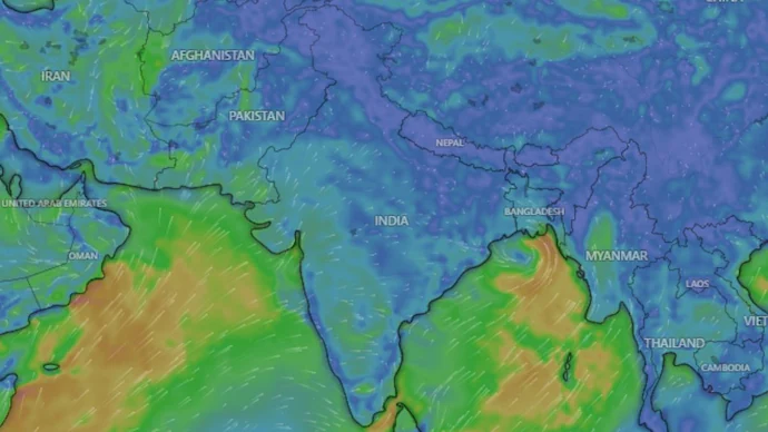
India’s southwest monsoon has entered a temporary “break phase”, leaving large parts of the country with below-normal rainfall despite covering the entire nation just days ago. While northeastern and Himalayan states continue to receive heavy showers, much of northwest, central and southern India is witnessing dry weather.
The India Meteorological Department (IMD) says rainfall is likely to remain subdued over several regions for the next week, although a fresh low-pressure system over the Bay of Bengal could help revive monsoon activity.
What Is a Monsoon Break?
A monsoon break is a temporary weakening of rainfall during the southwest monsoon season.
Normally, the monsoon trough—a long belt of low pressure stretching across northern India—draws moisture inland and produces widespread rainfall.
During a break phase:
- The monsoon trough shifts towards the Himalayan foothills.
- Heavy rain concentrates over the Northeast and Himalayan states.
- Central, western and peninsular India experience significantly reduced rainfall.
- Dry winds spread across many inland regions.
Meteorologists describe this as a natural part of the monsoon cycle, although the current break has become more pronounced than usual.
Rainfall Deficit Improves but Remains High
June was exceptionally dry across India.
The country received just 99.5 mm of rainfall, nearly 40% below normal, making it one of the driest Junes since weather records began in 1901.
Early July brought temporary relief after a depression formed over the Bay of Bengal, helping the monsoon cover the entire country by July 9, only one day behind schedule.
As a result:
- National rainfall deficit improved from 30% to around 14%.
- However, rainfall activity weakened again soon afterwards.
Why Is the Monsoon Weak This Year?
Several weather systems are combining to suppress rainfall across India.
1. El Niño Is Strengthening
The biggest factor is the return of El Niño, which refers to unusually warm ocean temperatures across the central and eastern Pacific Ocean.
El Niño disrupts global wind circulation and often weakens the Indian summer monsoon by reducing the amount of moisture transported towards the subcontinent.
2. Indian Ocean Dipole Remains Neutral
The Indian Ocean Dipole (IOD) can sometimes offset El Niño’s impact.
In years when the IOD turns strongly positive, India often receives better rainfall despite El Niño conditions.
This year, however, the IOD remains neutral, providing little support to the monsoon.
3. Madden-Julian Oscillation Is Unfavourable
Another important climate pattern, the Madden-Julian Oscillation (MJO), has remained in phases that suppress cloud formation and rainfall over India.
This has further weakened monsoon activity during July.
4. Fewer Low-Pressure Systems
Low-pressure systems developing over the Bay of Bengal are crucial for carrying moisture deep into central India.
So far this season, very few such systems have formed, limiting widespread rainfall across several states.
When Will the Monsoon Return?
Weather agencies are cautiously optimistic.
A fresh low-pressure area developed over the northwest Bay of Bengal on July 15, becoming only the second significant system of the season.
The IMD expects it to:
- Bring heavy to extremely heavy rainfall over Odisha until July 17.
- Increase rainfall across eastern India and parts of the Northeast.
- Move towards eastern Uttar Pradesh and the western Himalayan region.
- Potentially help shift the monsoon trough southward, ending the current break phase.
Some private weather forecasters also expect the system to strengthen further and spread rainfall into parts of central and western India, including Gujarat.
What Does This Mean for Farmers?
A prolonged break during July can affect:
- Sowing of kharif crops.
- Soil moisture levels.
- Reservoir storage.
- Irrigation demand.
However, if rainfall revives during the second half of July and August, much of the current deficit could still be recovered.
Can El Niño Still Cause Drought?
Not necessarily.
While El Niño increases the risk of below-normal rainfall, its overall impact depends on several other climate factors, including the Indian Ocean Dipole and the formation of low-pressure systems.
Meteorologists will closely monitor these patterns over the coming weeks before assessing the season’s overall performance.
Outlook
Although India’s monsoon has entered a temporary lull, weather experts do not consider the season over. The newly formed Bay of Bengal low-pressure system could bring much-needed rainfall to several regions and help revive monsoon activity. However, with El Niño continuing to strengthen, rainfall is likely to remain uneven, making the coming weeks crucial for agriculture, water resources and overall monsoon performance.
FAQs
1. What is a monsoon break?
A monsoon break is a temporary period during the southwest monsoon when rainfall decreases significantly across central, western and southern India while the Himalayan region and Northeast receive heavier rain.
2. Why has India’s monsoon weakened in July 2026?
The slowdown is mainly due to a strengthening El Niño, an unfavourable Madden-Julian Oscillation (MJO), a neutral Indian Ocean Dipole (IOD), and fewer low-pressure systems over the Bay of Bengal.
3. What is El Niño and how does it affect India’s monsoon?
El Niño is the warming of sea surface temperatures in the central and eastern Pacific Ocean. It disrupts global weather patterns and often weakens India’s southwest monsoon by reducing moisture transport.
4. What is the current rainfall deficit in India?
India’s rainfall deficit has improved to around 14%, down from nearly 30% earlier in the season after widespread rains in early July.
5. When is the monsoon expected to revive?
The IMD expects a fresh low-pressure system over the Bay of Bengal to increase rainfall across eastern India and potentially revive monsoon activity over central and western regions in the coming days.
6. Which states are expected to receive heavy rainfall?
Odisha, Gangetic West Bengal, parts of Northeast India, eastern Uttar Pradesh and the western Himalayan region are likely to receive heavy rainfall as the new weather system moves inland.
7. What role does the Indian Ocean Dipole play?
A positive Indian Ocean Dipole can reduce El Niño’s negative impact on India’s monsoon. However, the IOD remains neutral this year, offering little support.
8. Will the weak monsoon affect agriculture?
Extended dry spells can delay sowing, reduce soil moisture and increase irrigation needs. However, a strong revival later in the season could help recover much of the rainfall deficit.
9. Is the current monsoon break unusual?
Monsoon breaks are a normal feature of India’s rainy season, but this is among the more significant July break phases observed over the past decade.
10. Can India still record normal monsoon rainfall this year?
Yes. Much depends on rainfall during the second half of July, August and September. A revival in monsoon activity could still narrow the rainfall deficit substantially.
Leave a Reply