
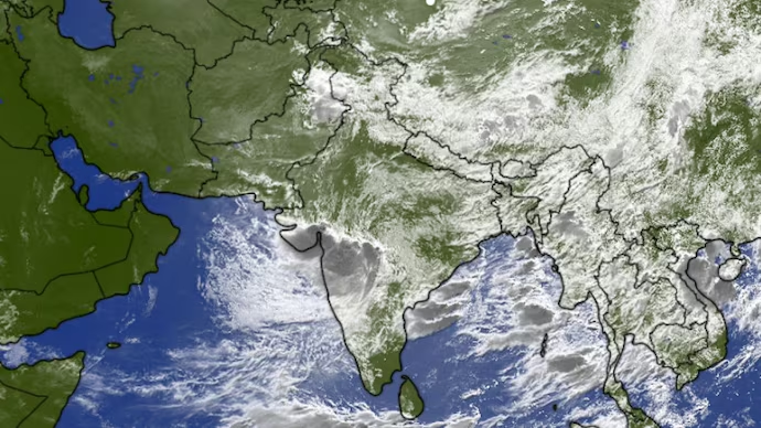
India’s monsoon has entered one of its most active phases, with seven different weather systems working simultaneously to influence rainfall across the country. Meteorologists say this rare combination is expected to trigger widespread heavy rainfall, increase flood risks and shift the focus of intense showers toward the Himalayan foothills, Bihar, Assam and northeastern India over the next few days.
From a moisture-laden jet stream over the Arabian Sea to a deep depression moving across western India, each weather system is contributing to the evolving monsoon pattern.
1. Somali Jet: The Monsoon’s Moisture Engine
The Somali Jet, also known as the Findlater Jet, is a powerful low-level wind current that originates near Madagascar before crossing the Arabian Sea into India.
Flowing about 1.5 kilometres above sea level, it transports massive amounts of moisture from the warm Arabian Sea. As the jet strengthens, it supplies the atmosphere with the water vapour needed to fuel widespread rainfall across the Indian subcontinent.
2. Deep Depression Over Western India
A deep depression that formed over the Bay of Bengal crossed the eastern coast before moving inland across central India and is now tracking toward Gujarat.
The system pulls moist air inward, forcing it to rise and condense into rain-bearing clouds. This process releases latent heat, helping sustain the weather system and produce prolonged spells of heavy rainfall.
Meteorologists have warned of extremely heavy rainfall over parts of Gujarat, with isolated locations likely to receive more than 21 centimetres of rain in a single day.
3. Northward Shift of the Monsoon Trough
The monsoon trough, a long belt of low pressure stretching across northern India, plays a crucial role in determining where the heaviest rainfall occurs.
As the deep depression weakens and moves westward, the trough is expected to shift north toward the Himalayan foothills. This movement will redirect the heaviest rainfall away from central India toward Bihar, eastern Uttar Pradesh, Uttarakhand, Himachal Pradesh and northeastern states.
4. East-West Shear Zone Intensifies Rainfall
An east-west shear zone located over central India is enhancing atmospheric instability by creating sharp changes in wind direction and speed at different heights.
This feature helps organise cloud bands and intensifies rainfall over central parts of the country.
5. Offshore Trough Sustains Rain Along the West Coast
An offshore trough extending from south Gujarat to north Kerala continues to maintain active monsoon conditions along India’s western coastline.
Konkan, Goa and coastal Karnataka are expected to receive persistent rainfall as moist winds from the Arabian Sea continue moving inland.
6. Western Disturbance Strengthens Rain in the North
A Western Disturbance over northwestern India is interacting with moisture carried by the monsoon.
This interaction is expected to enhance rainfall over Punjab, Haryana, Jammu and Kashmir, Himachal Pradesh and Uttarakhand, increasing the likelihood of landslides and flash floods in hilly regions.
7. Cyclonic Circulation Over Assam
A low-level cyclonic circulation over central Assam continues to feed moisture into northeastern India.
Combined with the northward movement of the monsoon trough, the system is likely to produce widespread rainfall across Assam and neighbouring states, where river levels are already elevated.
Regions Facing the Highest Flood Risk
The combined influence of these weather systems is expected to create significant flood threats in several regions:
- Upper Assam and the Brahmaputra basin
- North Bihar and eastern Uttar Pradesh
- Himalayan foothills, including Uttarakhand and Himachal Pradesh
- Parts of Gujarat, Maharashtra and Madhya Pradesh
Authorities have advised residents in flood-prone and landslide-prone areas to remain alert, monitor official weather updates and avoid unnecessary travel during periods of intense rainfall.
Positive Impact for Agriculture
Despite the risk of flooding, widespread rainfall will also provide important benefits for agriculture and water resources.
The rains are expected to:
- Replenish reservoirs and groundwater levels
- Improve irrigation availability
- Support kharif crops such as paddy, cotton, pulses and oilseeds
- Enhance drinking water supplies and hydropower generation
However, experts caution that excessive rainfall over short periods can damage standing crops, erode soil and reduce agricultural productivity.
Monsoon Activity to Remain Vigorous
Meteorologists expect active monsoon conditions to continue over the coming days as these interconnected weather systems influence rainfall across different regions of the country. The exact distribution and intensity of rainfall will depend on how these systems evolve and interact with one another.
Frequently Asked Questions (FAQs)
Q1. Why is India’s monsoon unusually active this week?
Seven weather systems, including a deep depression, Somali Jet, monsoon trough, offshore trough, shear zone, Western Disturbance and cyclonic circulation, are interacting simultaneously to strengthen rainfall.
Q2. Which areas face the highest flood risk?
Upper Assam, Bihar, eastern Uttar Pradesh, Uttarakhand, Himachal Pradesh, Gujarat, Maharashtra and parts of Madhya Pradesh face an increased risk of flooding, flash floods and landslides.
Q3. What is the Somali Jet?
The Somali Jet is a strong low-level wind current over the Arabian Sea that transports moisture into India, acting as one of the primary drivers of the southwest monsoon.
Q4. How does a deep depression affect rainfall?
A deep depression pulls in moist air, forcing it upward to form rain clouds, resulting in widespread and often heavy rainfall over affected regions.
Q5. Will the heavy rainfall benefit farmers?
Yes. Adequate rainfall helps replenish reservoirs, recharge groundwater and support kharif crops, although excessive rainfall over a short period can damage crops and cause soil erosion.